


利悅最新裝盒機(jī)案例及視頻展示
LATEST BOXING MACHINE CASES AND VIDEO


利悅裝盒包裝生產(chǎn)線(xiàn)案例
BOXING MACHINE PACKAGING LINE


利悅標(biāo)準(zhǔn)裝盒機(jī)機(jī)型
BOXING MACHINE MODEL


利悅標(biāo)準(zhǔn)裝箱機(jī)機(jī)型
CASE PACKING MACHINE MODEL


關(guān)于利悅 利鈞盒機(jī)
ABOUT LIYUE
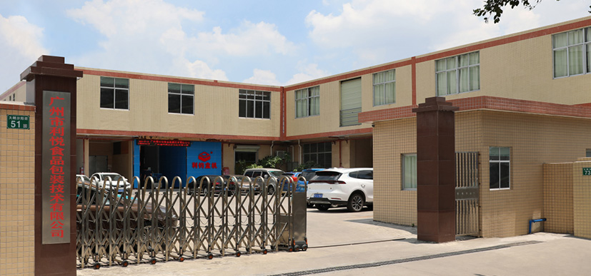
17年專(zhuān)注后段非標(biāo)包裝機(jī)械,擁有自主技術(shù)知識(shí)產(chǎn)權(quán)
廣州市利悅食品包裝技術(shù)有限公司是廣東首家全省性機(jī)器人行業(yè)協(xié)會(huì)發(fā)起單位之一、廣東省包裝行業(yè)商會(huì)第一屆理事會(huì)常務(wù)理事單位、廣東省食品和包裝機(jī)械工業(yè)協(xié)會(huì)會(huì)員單位。
專(zhuān)業(yè)從事后段非標(biāo)包裝機(jī)械研發(fā)生產(chǎn)制造及包裝生產(chǎn)連線(xiàn)解決方案提供商。產(chǎn)品有自動(dòng)裝盒機(jī)、折盒機(jī)、封盒機(jī)、開(kāi)箱裝箱封箱等非標(biāo)包裝機(jī)械,擁有100多名研發(fā)及生產(chǎn)制造團(tuán)隊(duì),提供一對(duì)一的售后服務(wù),是一家集研發(fā)、制造、銷(xiāo)售、服務(wù)為一體的綜合性企業(yè)。
自成立以來(lái),先后為1000多家企業(yè)實(shí)現(xiàn)了用機(jī)器替代人手包裝,讓他們?cè)诩ち业氖袌?chǎng)競(jìng)爭(zhēng)中,降低成本,提高產(chǎn)能。
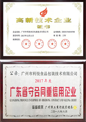
守合同重信用|高新技術(shù)企業(yè)
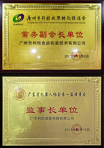
廣州市科技成果轉(zhuǎn)化促進(jìn)會(huì)常務(wù)副會(huì)長(zhǎng)單位
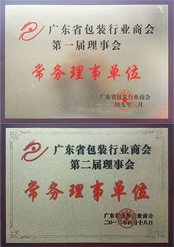
廣東省包裝行業(yè)商會(huì)常務(wù)理事單位
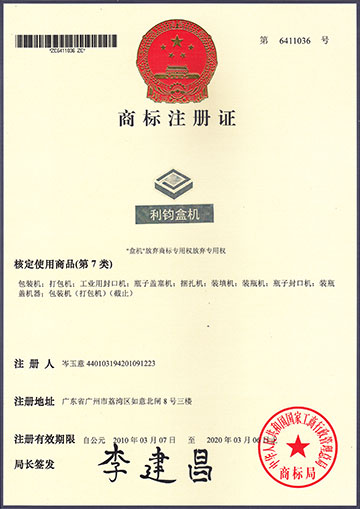
利鈞盒機(jī)品牌商標(biāo)
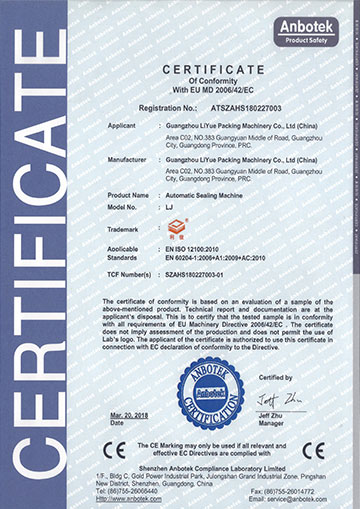
CE證書(shū)
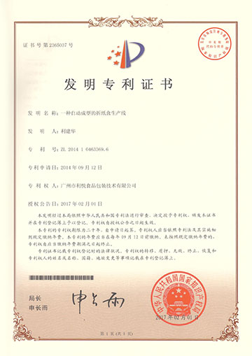
自動(dòng)成型折紙盒生產(chǎn)線(xiàn)發(fā)明專(zhuān)利
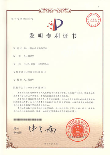
壓蓋包裝機(jī)發(fā)明專(zhuān)利
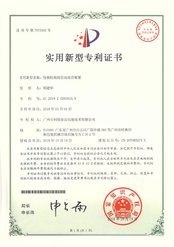
包裝機(jī)自動(dòng)扣盒裝置新型專(zhuān)利
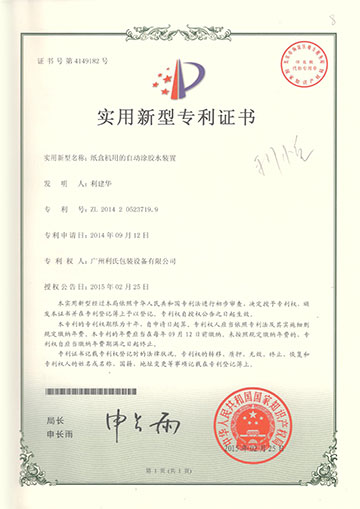
包裝機(jī)自動(dòng)涂膠水新型專(zhuān)利
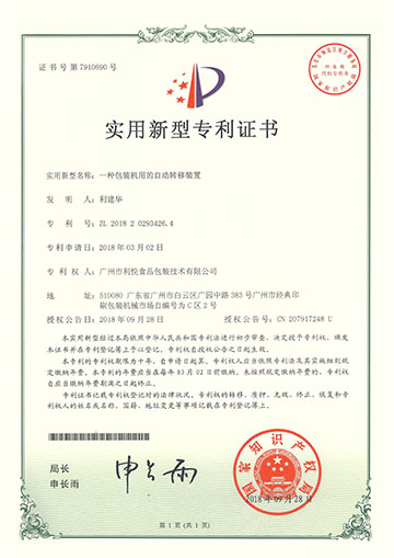
包裝機(jī)自動(dòng)轉(zhuǎn)移裝置新型專(zhuān)利


文章資訊
07.11
2020
裝盒機(jī)調(diào)機(jī)步驟及圖解(不同尺寸規(guī)格紙盒裝盒切換)
如果你的包裝產(chǎn)品的紙盒有更換,即現(xiàn)有的紙盒大小尺寸和之前發(fā)生不一樣時(shí),則需要結(jié)合以下步驟進(jìn)行裝盒...
查看詳情07.11
2020
利悅插盒自動(dòng)裝盒機(jī)使用說(shuō)明書(shū)
本機(jī)是集開(kāi)盒、裝料、折盒、封盒為一體的包裝機(jī),適用于多品種,多規(guī)格的紙盒包裝,由PLC微電腦控制,自動(dòng)報(bào)警...
查看詳情07.02
2020
廣州利悅包裝夏日歡喜三日游,陽(yáng)江閘坡大角灣|天露山禪龍峽|鶴山古勞
相親相愛(ài)一家人,為豐富家人文化生活,增進(jìn)團(tuán)隊(duì)凝聚力,2020年6月29日公司組織連續(xù)三日的歡喜旅游。陽(yáng)江閘...
查看詳情06.16
2020
裝盒機(jī)英語(yǔ)怎么說(shuō)?裝盒機(jī)英文翻譯。
常見(jiàn)的英語(yǔ)翻譯有:cartoning machine; boxing machine,下面利悅包裝為大家講解裝盒機(jī)正確的翻譯是什么。...
查看詳情06.11
2020
粘膠裝盒機(jī)用什么膠水?
粘膠裝盒機(jī)所用的膠水是熱熔膠膠粒,膠粒可能有些人會(huì)比較陌生,膠條可能大家就比較熟悉。...
查看詳情06.09
2020
裝盒機(jī)市場(chǎng)及未來(lái)20年發(fā)展趨勢(shì)(利悅分享)
通過(guò)在網(wǎng)上搜索了下,“裝盒機(jī)市場(chǎng)”和“裝盒機(jī)趨勢(shì)”,都是人云亦云,互相抄襲轉(zhuǎn)發(fā),甚至有些寫(xiě)的不知...
查看詳情06.04
2020
臥式自動(dòng)裝盒機(jī)特點(diǎn)及裝盒流程
臥式裝盒機(jī)通過(guò)一根推料桿水平將產(chǎn)品推入紙盒當(dāng)中,塊狀固體的產(chǎn)品均可通過(guò)推料實(shí)現(xiàn)裝盒,可帶說(shuō)明書(shū)一...
查看詳情06.02
2020
二手裝盒機(jī)購(gòu)買(mǎi)注意事項(xiàng)非常重要
買(mǎi)過(guò)二手裝盒機(jī)的的客戶(hù)朋友都知道,購(gòu)買(mǎi)二手裝盒機(jī)跟購(gòu)買(mǎi)二手汽車(chē)是一樣的,二手裝盒機(jī)首當(dāng)其沖關(guān)注裝...
查看詳情